Free · No sign-up · Runs in your browser
Your course. One map.
Ready to print.
DiscMap is a free course design tool built for disc golf. Place tee pads, baskets, mandos, OB and drop zones on real terrain, and every distance, hole sign, info board and caddie book is generated from that one map — move a basket and the whole set follows.
184 courses mapped with DiscMap so far
- No account needed
- Metric or imperial
- Print-ready vector PDFs
- OpenStreetMap terrain
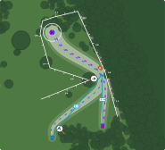
Vector render of Bitwa o Golę 2026 — a real course mapped in DiscMap.
One map, every output
Measured, not sketched
Tees and baskets sit on real coordinates, so distances are computed from the geometry instead of typed in by hand — and they update the moment a pin moves.
Print-ready by design
Every export is drawn as vector at page size — A4 or Letter tee signs, an 18 × 24 in info board — so text stays crisp at any print size instead of pixelating like a screenshot.
Built for disc golf
Mandos, OB lines and zones, drop zones, hazards, tee layouts and per-layout par are first-class objects, not generic map pins with a label stuck on them.
How it works
Five steps from an empty map to a folder of print-ready PDFs. The app walks you through them in order and remembers where you stopped.
Find your grounds
Search for the park or drop a pin, and DiscMap pulls the terrain around it from OpenStreetMap — woods, paths, water and buildings — as the base your holes are drawn on.
Place tees and baskets
Click a tee, click its basket, and the fairway corridor draws itself along the flight path. Drag the control points to bend it around the dogleg the hole actually plays.
Add what makes it readable
Trees, OB, mandos, drop zones, surfaces and landmarks. This is the part that turns a line between two points into a map a first-time visitor can navigate.
Design the signage
Pick a template and a print colour; the hole sign, the info board and the caddie book fill themselves in from the map — course name, hole number, par, distances per tee layout, your notes and sponsor logos.
Print and share
Export vector PDFs for the sign shop, and hand players a public course page with a QR code you can drop straight onto the tee sign.
There are no accounts. A course is its edit link — keep it and you can come back and change anything; share it and whoever has it can edit too.
Same map. Every printout.
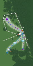
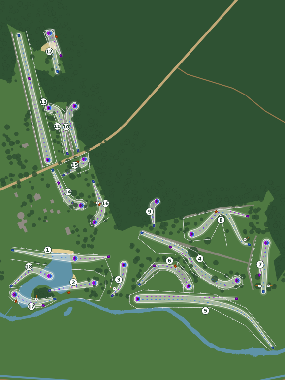
Both prints below come from one real course — Bitwa o Golę 2026: 18 holes and the Long / Short tee layouts drawn in DiscMap. Nothing here is a mock-up; they are rendered by the same code that produces the PDFs.
What you can draw and print
Everything below is in the app today. It is free while DiscMap is in development, and there is no paid tier waiting behind a feature you are already using.
Tee pads and baskets
Oriented tee pads and baskets with putting circles, placed by clicking the map. Distances follow automatically.
Multiple tee layouts
Long, short, red, blue — as many routes per hole as the course plays, each with its own colour and par. Shared tees and baskets are drawn multi-coloured so a sign shows every layout at once.
Mandos, OB and drop zones
Mandatory routes, OB lines and OB areas, drop zones and hazards, drawn the way the rules read them.
Surfaces and vegetation
Fairway, rough, green, sand, water, pavement, woods and clearings — painted as areas so a hole reads at a glance.
Individual trees
Place trees with real crown sizes where they matter to the line, and let the imported forest cover the rest.
OpenStreetMap import
The surrounding paths, woods, water and buildings come in from OSM and are restyled to match your map instead of sitting under a screenshot of a tile server.
Tee signs and info boards
A4, Letter or 18 × 24 in, as vector PDF. One print colour per course keeps the whole set consistent.
Caddie book
A per-hole book with the same maps, your own text, images and tables — as a PDF and as pages players can read on a phone.
Sponsor logos
Upload a sponsor's logo once and place it on the signs and the board; it is rasterised properly for print, not stretched.
Public course page and QR
A read-only page for players with every hole, par, distance and note — reachable by a QR code you can print on the sign.
Metric or imperial
Pick per course. Signs can show both at once when your visitors are split.
Distance markers
Measuring tapes and markers you place yourself, for the numbers a player wants that a straight tee-to-basket line does not answer.
Who it is for
Clubs putting up their first signs
A course that grew out of a club WhatsApp group usually has no drawings at all. This gets you a full set of tee signs and a board without hiring a designer.
Tournament directors
Draw the tournament layout alongside the everyday one, print the signs for the weekend, and hand players a caddie book with your own hole notes.
Course designers
Try a routing on real terrain with real distances before anything is installed, and show the landowner a map instead of a sketch.
Parks and landowners
See exactly where a course puts traffic, OB and out-of-play areas, on a map that matches the paths and woods already on the ground.
Questions
If something here is not answered, the app is the fastest way to find out — starting a course costs nothing and takes a name.
Is DiscMap really free?
Yes. DiscMap is free to use while it is in development, including the PDF exports. There is no trial timer, no watermark on your prints and no feature that stops working after a while.
Do I need an account?
No. There is no sign-up. Creating a course gives you a private edit link, and that link is what grants access — keep it somewhere safe, because anyone who has it can edit the course, and losing it means losing the course.
What can I actually print?
Per-hole tee signs in A4 or Letter, a whole-course info board at 18 × 24 inches, and a caddie book. All three are exported as vector PDFs, so a print shop can scale them up without the map turning into pixels.
Are the distances accurate?
Distances are measured from the coordinates you place tees and baskets at, along the flight path you draw, so they are as accurate as your placement. Working from a satellite image typically lands within a few metres — good enough for a sign, and much closer than a hand-paced estimate. For a certified measurement, walk it with a laser.
Can one hole have several tee positions?
Yes. A hole can carry as many layouts as it plays — long and short, or PDGA-style red, white, blue and gold — each with its own colour, its own par and its own measured distance. Signs and the caddie book list every layout, and a tee or basket shared by several layouts is drawn in all of their colours.
Metric or feet?
Both. Units are chosen per course, and the sign templates can print metres and feet side by side when your visitors are split between the two.
Where does the background map come from?
The terrain around your course — paths, woods, water, buildings — is imported from OpenStreetMap and redrawn in DiscMap's own styling, so exports stay vector and stay legible in print. OpenStreetMap contributors are credited on every page and in the exports.
Can players see the course online?
Every course gets a public, read-only page with all of its holes, pars, distances and hole notes. It is designed to be reached from a QR code on the tee sign, and it never exposes the edit link.
Can I come back and change the course later?
Yes, as long as you have the edit link. Courses are meant to be edited over years — move a basket after a redesign, add a tournament layout, then re-export the signs that changed.
What is not finished yet?
DiscMap is in active development. Saved work can occasionally break, and features move around between visits. If a course matters to you, export the PDFs you need rather than treating the app as the only copy.
Map your course
A name and your units is all it takes to start. Everything after that is clicking on a map.