Disc golf course design software, free in your browser
DiscMap is a course design tool made only for disc golf. You plan the routing on the real terrain of your park, every distance is measured from the geometry, and the same map later prints your tee signs, info board and caddie book. There is nothing to install and no account to create.
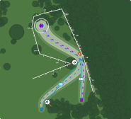
What you can design
General-purpose map tools can draw a line between two points; they cannot tell you it is a par 3 with a mando and an OB road on the left. In DiscMap the disc golf objects are the tool:
- Tee pads and baskets with orientation and putting circles, placed on the map.
- Fairway corridors that follow the flight path — drag the control points around a dogleg and the length updates.
- As many tee layouts per hole as the course plays, each with its own colour and par.
- OB lines and areas, mandos, drop zones and hazards.
- Surfaces (fairway, rough, green, sand, water, woods) and individual trees with real crown sizes.
- Distance markers and measuring tapes for the numbers a straight tee-to-basket line does not answer.
Planning a new course on real terrain
Start by searching for the park: DiscMap imports the paths, woods, water and buildings around it from OpenStreetMap and redraws them as the base of your map. That is usually enough to see where holes can fit, where they would cross a footpath, and where the woods leave a playable corridor.
A few rules of thumb experienced designers work to, and that are easy to check on the map: keep a mix of hole lengths rather than eighteen of the same; do not let a fairway's landing zone overlap a path or another hole's tee; keep the walk from each basket to the next tee short and obvious; and plan a short and a long tee from the start, because adding a second layout later is much harder on the ground than on the map.
Showing it to a landowner or a club
A routing drawn on the park's own paths and woods, with every OB zone and every tee where it would really go, is a far easier conversation with a council or a landowner than a sketch. Share the course's public page — a read-only map with every hole — and they can look at it on their own phone.
From design to signs
Because the design is a real map, it is also the source for the signage: tee signs in A4 or Letter, an 18 × 24 in info board and a caddie book, all as vector PDFs. When a hole is redesigned, you move the basket once and re-export the signs that changed.
What it is not
DiscMap is not CAD or survey software. Distances are measured from where you place tees and baskets, usually on a satellite or OpenStreetMap base — typically within a few metres, which is right for planning and signage. For a certified measurement, walk the hole with a laser rangefinder.
Questions
- Is this disc golf course design software free?
- Yes. DiscMap is free to use, including exports, and there is no paid tier behind the design tools.
- Do I need to install anything or create an account?
- No. It runs in a modern browser. Creating a course gives you a private edit link; keep it, because that link is what lets you edit the course later.
- Can I design several layouts for the same course?
- Yes. Each hole can carry as many tee layouts as it plays, with separate par and measured distance, and signs list all of them.
- Can I work in feet?
- Yes. Units are set per course — metres or feet — and signs can print both.